In the dynamic realm of geoscience, having the right tools at your disposal is paramount for meaningful exploration and analysis. GeoMapApp emerges as a beacon in this landscape, offering a map-based application that goes beyond expectations. Let’s delve into the world of Free Geology Mapping Software – GeoMapApp and unravel its potential.
What is GeoMapApp?
GeoMapApp is a cutting-edge, map-based application designed to facilitate the exploration, visualization, and analysis of a diverse array of global and regional geoscience datasets. From geophysics and geology to geochemistry, physical oceanography, and climatology, GeoMapApp covers it all. The cherry on top? It’s free.
Key Features
1. Data Diversity
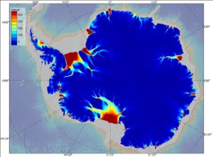
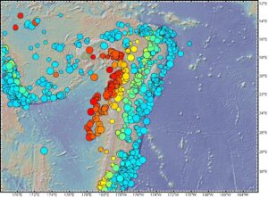
GeoMapApp boasts a curated selection of datasets spanning various disciplines. Users can immerse themselves in geophysics, geology, geochemistry, physical oceanography, climatology, and more.
2. Customization Tools
Tailor your visual experience with data layering, display customization, and analytical tools. GeoMapApp provides flexibility, allowing users to choose from Mercator, North polar, and South polar projections. Customize colors, shading, and contours to meet your analysis needs.
3. Import Capabilities
Make GeoMapApp your own by importing grids, tabular data, images, and shapefiles. Whether it’s custom grids or external data, the application ensures adaptability. Users can even edit table values, adjust map symbols, colors, and sizes.
4. Specialized Portals
Dive into specialized portals for enhanced visualization and basic analysis. Examples include seismic reflection profiles and geodetic velocity vectors, previously requiring specialized software.
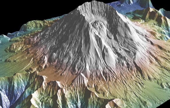
5. GMRT Base Map
Leverage the multi-resolution global elevation data provided by the GMRT base map. It serves as a solid foundation upon which other datasets can be seamlessly layered.
System Requirements
For those eager to embark on a geoscientific journey with GeoMapApp, it’s essential to meet the system requirements. The application runs on Java and supports Windows, Mac OS X, Linux, and Unix/Solaris operating systems.
Conclusion
GeoMapApp opens the door to a world of geoscientific exploration. With its user-friendly interface, diverse datasets, and customization options, it’s a powerful ally for researchers, scientists, and enthusiasts. Dive into the depths of GeoMapApp, where geology meets technology in perfect harmony.
We use cookies on our website to give you the most relevant experience by remembering your preferences and repeat visits. By clicking “Accept All”, you consent to the use of ALL the cookies. However, you may visit "Cookie Settings" to provide a controlled consent.
This website uses cookies to improve your experience while you navigate through the website. Out of these, the cookies that are categorized as necessary are stored on your browser as they are essential for the working of basic functionalities of the website. We also use third-party cookies that help us analyze and understand how you use this website. These cookies will be stored in your browser only with your consent. You also have the option to opt-out of these cookies. But opting out of some of these cookies may affect your browsing experience.
Necessary cookies are absolutely essential for the website to function properly. These cookies ensure basic functionalities and security features of the website, anonymously.
Cookie
Duration
Description
cookielawinfo-checkbox-analytics
11 months
This cookie is set by GDPR Cookie Consent plugin. The cookie is used to store the user consent for the cookies in the category "Analytics".
cookielawinfo-checkbox-functional
11 months
The cookie is set by GDPR cookie consent to record the user consent for the cookies in the category "Functional".
cookielawinfo-checkbox-necessary
11 months
This cookie is set by GDPR Cookie Consent plugin. The cookies is used to store the user consent for the cookies in the category "Necessary".
cookielawinfo-checkbox-others
11 months
This cookie is set by GDPR Cookie Consent plugin. The cookie is used to store the user consent for the cookies in the category "Other.
cookielawinfo-checkbox-performance
11 months
This cookie is set by GDPR Cookie Consent plugin. The cookie is used to store the user consent for the cookies in the category "Performance".
viewed_cookie_policy
11 months
The cookie is set by the GDPR Cookie Consent plugin and is used to store whether or not user has consented to the use of cookies. It does not store any personal data.
Functional cookies help to perform certain functionalities like sharing the content of the website on social media platforms, collect feedbacks, and other third-party features.
Performance cookies are used to understand and analyze the key performance indexes of the website which helps in delivering a better user experience for the visitors.
Analytical cookies are used to understand how visitors interact with the website. These cookies help provide information on metrics the number of visitors, bounce rate, traffic source, etc.
Advertisement cookies are used to provide visitors with relevant ads and marketing campaigns. These cookies track visitors across websites and collect information to provide customized ads.