Introduction
Have you ever wondered how geologists gain insights into the Earth’s history, structure, and resources? Look no further than the humble yet powerful tool known as a geologic maps. This intricate mosaic of colors, lines, and symbols unlocks the geological history of our planet, providing valuable information to geologists, researchers, and even curious explorers. In this article, we will embark on a journey to understand what a geological map is, delve into its origins and creation, decipher its symbols, explore the information it provides, and uncover its global availability.
What is a Geological Map?
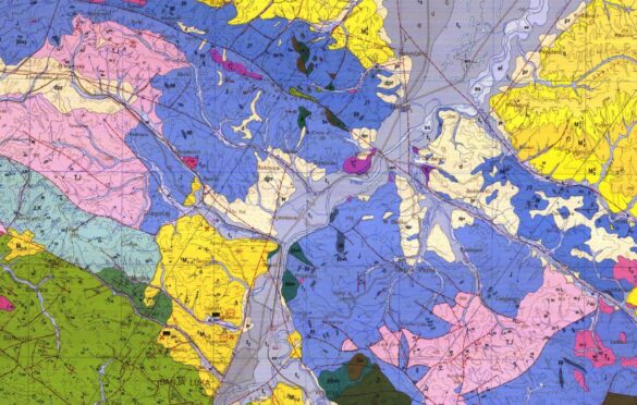
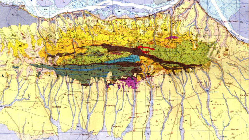
A geological map is a visual representation of the geological features present on the Earth’s surface or subsurface. It is a cartographic masterpiece that illustrates the distribution of different rock types, geological structures, mineral deposits, and other crucial elements. Geologists rely on these maps to comprehend the complex geological history of a region and aid in decision-making for various industries like mining, construction, and environmental planning.
Origin or History of the Geological Map
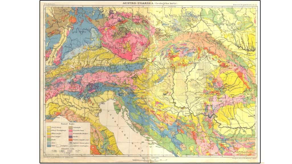
The inception of geological mapping can be traced back to the late 18th century when geologists like William Smith and Georges Cuvier recognized the significance of rock layers and the fossils contained within them. Smith, often referred to as the “Father of English Geology,” published the first geological map of England, Wales, and part of Scotland in 1815. His map showcased the stratigraphic succession of rock layers and their fossil content, laying the groundwork for modern geologic mapping.
In the early 19th century, Europe witnessed an explosion of geological mapping efforts, with renowned geologists like Charles Lyell, Henry De la Beche, and Roderick Murchison contributing significantly to the field. The geological maps of this era were hand-drawn with meticulous precision, reflecting the dedication and passion of early geologists.
How to Make Geological Maps?
Creating a geological map is a complex and time-consuming process that requires interdisciplinary skills and expertise. Below are the key steps involved in making a geological map:
Fieldwork and Surveys: Geologists venture into the field to observe, collect samples, and record geological features. They use various tools like compasses, GPS devices, and geological hammers to gather essential data.
Compilation and Interpretation: Back in the laboratory, geologists analyze the collected data, classify rock types, identify geological structures, and interpret the geological history of the area.
Digitization and Mapping: With the advent of technology, field data is now digitized using Geographic Information Systems (GIS). Specialized software helps geologists create digital geological maps, which are more accessible and user-friendly.
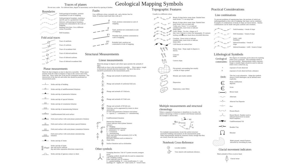
Symbolization: Geologic maps use a standardized set of symbols and colors to represent different rock types, faults, folds, and other geological features. This symbolism helps convey complex information effectively.
Publication and Dissemination: Once the map is complete, it undergoes rigorous peer review before publication. These maps are often made available to the public, researchers, and various industries, aiding in sustainable development and resource management.
Orientation of Geological Maps
Properly orienting a geological map is crucial for accurate interpretation and analysis. Geologists use a combination of cardinal directions and map symbols to represent the orientation of geological features:
Strike and Dip: Strike is the compass direction of a rock layer or fault as it intersects with the horizontal plane. Dip, on the other hand, indicates the angle of the rock layer or fault from the horizontal plane. This information helps geologists understand the spatial arrangement of rock layers in three-dimensional space.
Compass Rose: A compass rose on a geological map indicates the true north direction, helping users align the map with the actual geographical north.
Symbols on a Geological Maps
Geological maps employ a variety of symbols to represent geological features and structures. These symbols serve as a visual shorthand, conveying a wealth of information at a glance. Some common symbols include:
Rock Types: Different rock types, such as igneous, sedimentary, and metamorphic, are represented by unique colors or patterns on the map.
Geological Structures: Symbols depict geological structures like folds, faults, and joints, offering insights into the tectonic history of the region.
Mineral Deposits: Important mineral deposits, such as ore bodies, are often marked on geological maps, aiding in mineral exploration and extraction.
Fossils: Fossils are valuable indicators of the geological age of rock layers and are represented using specific symbols.
What Information do Geological Maps Provide?
Geological maps are veritable treasure troves of information that unlock the Earth’s history and potential resources. Here are some key insights they offer:
Stratigraphy: Geological maps reveal the arrangement and ages of rock layers, providing valuable information about the geological history of a region.
Structural Geology: By illustrating folds, faults, and other structures, these maps shed light on the tectonic forces that shaped the landscape.
Resource Exploration: Geological maps aid in locating valuable resources such as minerals, water, and hydrocarbons, supporting responsible and sustainable resource exploration.
Natural Hazards: Understanding geological features can help predict and manage natural hazards like earthquakes, landslides, and volcanic eruptions.
Environmental Planning: Geological maps are crucial for urban planning, infrastructure development, and environmental conservation efforts.
Do All Countries Have Geological Maps?
While geological mapping efforts are more pronounced in developed countries with established geological surveys, efforts are being made worldwide to create comprehensive geological maps. Some countries might have more detailed maps due to their geological significance or the presence of valuable resources.
However, in recent years, international collaborations, advancements in technology, and open-access data initiatives have improved accessibility to geological information for researchers and geologists worldwide. Various geological organizations, like the United States Geological Survey (USGS), the British Geological Survey (BGS), and the Geological Survey of Canada (GSC), are actively involved in geological mapping and provide valuable resources.
Where Can I Get Geological Maps?
The digital age has made accessing geological maps more convenient than ever before. Several online platforms offer access to geological maps from around the world. Here are some reliable sources to explore:
Geological Surveys: Many countries have geological survey websites that provide free access to their geological maps and related data.
USGS National Geologic Map Database: The USGS offers a comprehensive database of geological maps covering the United States and other regions.
European Geological Data Infrastructure (EGDI): The EGDI is an excellent resource for geological maps of European countries.
OneGeology: This international initiative provides access to geological maps from various geological surveys around the world.
Conclusion
Geological maps have undoubtedly transformed the way we understand and interact with our planet. From uncovering the Earth’s ancient history to guiding resource exploration and environmental planning, these maps serve as windows into the dynamic world beneath our feet. As we continue to advance technologically and collaborate internationally, geological mapping will remain a fundamental tool in exploring the geological wonders of our world, inspiring future generations of geologists to unravel Earth’s many mysteries. So, the next time you gaze upon a geological map, remember that it represents the culmination of centuries of dedicated exploration, revealing the secrets of our ancient and ever-changing planet. Happy mapping