What is geotechnical engineering?

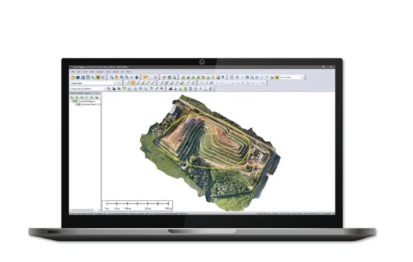
Global Mapper is a powerful, yet affordable GIS and mapping software that has become increasingly popular in the geology, engineering geology, and geotechnics fields. It is a comprehensive solution that provides a wide range of features and tools that enable geologists, engineers, and technicians to easily create and analyze maps, perform spatial analysis, and visualize 3D terrain models. In this article, we will examine the key features and benefits of Global Mapper, and why it is an essential tool for professionals working in these fields.
Extensive data import and export capabilities: Global Mapper supports over 300 different data formats, making it easy to import and export data from various sources, including satellite imagery, topographic maps, and geospatial data.
Advanced spatial analysis tools: The software provides a comprehensive set of tools for analyzing and manipulating geospatial data, including raster and vector data processing, elevation analysis, terrain modeling, and more.
3D visualization and terrain modeling: Global Mapper allows users to create detailed 3D terrain models, including digital elevation models (DEMs), TINs, and 3D views of geospatial data. This enables geologists, engineers, and technicians to easily visualize and analyze complex geological and geotechnical data in a 3D environment.
Integration with other software: Global Mapper integrates seamlessly with other software, including CAD and GIS applications, allowing users to easily exchange data and work with other professionals in their field.

Global Mapper is a versatile and powerful software that provides an essential set of tools for geologists, engineers, and technicians working in the fields of geology, engineering geology, and geotechnics. With its extensive data import and export capabilities, advanced spatial analysis tools, and 3D visualization and terrain modeling, it is the ideal solution for professionals who require a comprehensive and affordable mapping and GIS software. Whether you are working on a large-scale geology project or performing detailed geotechnical analysis, Global Mapper is the right choice for you.

What is geotechnical engineering?


Petroleum Geologist Salary: An In-Depth Guide
| Cookie | Duration | Description |
|---|---|---|
| cookielawinfo-checkbox-analytics | 11 months | This cookie is set by GDPR Cookie Consent plugin. The cookie is used to store the user consent for the cookies in the category "Analytics". |
| cookielawinfo-checkbox-functional | 11 months | The cookie is set by GDPR cookie consent to record the user consent for the cookies in the category "Functional". |
| cookielawinfo-checkbox-necessary | 11 months | This cookie is set by GDPR Cookie Consent plugin. The cookies is used to store the user consent for the cookies in the category "Necessary". |
| cookielawinfo-checkbox-others | 11 months | This cookie is set by GDPR Cookie Consent plugin. The cookie is used to store the user consent for the cookies in the category "Other. |
| cookielawinfo-checkbox-performance | 11 months | This cookie is set by GDPR Cookie Consent plugin. The cookie is used to store the user consent for the cookies in the category "Performance". |
| viewed_cookie_policy | 11 months | The cookie is set by the GDPR Cookie Consent plugin and is used to store whether or not user has consented to the use of cookies. It does not store any personal data. |