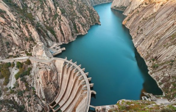
Dams are one of the most important development infrastructures in any country and are used for many different purposes including irrigation, water supply, flood control, electricity production (19% of worldwide supply) and storage of mine wastes. Economic growth is directly related to the construction of dams, with more than 45,000 worldwide considered as large dams (i.e. over 15 m high or with a reservoir capacity of over 3 million m3). The shortage of water resources is a major global problem: more than 1,000 million people do not have access to the minimum daily water requirement (50 litres per person/day) while in industrialized countries the consumption is 4–14 times this amount.
Geological investigation for dams
Geological investigation for dams are carried out depending on the different stages of the dam design and construction. Table 1 shows the sequence of these studies which are usually carried out as follows:
| Stage | Type of engineering geological investigations |
| Feasibility and preliminary studies |
Regional geology — Geological surveys — Reservoir water tightness — Materials — Slope stability — Silting and subsidence Preliminary investigations of dam sites — Geological structure — Geophysical surveys — Permeability estimation |
| Design | Dam site and reservoir characterization — Strength and deformability — Leakage — Auxiliary structures — Materials — Other problems |
| Construction | Geological and geomechanical assistance and control — Geological mapping — Geophysical surveys — Strength and deformability in situ tests — Grouting tests — Ground monitoring and control |
| Operation | Monitoring and control — Initial reservoir filling — Emergency situations — Safety analysis |
Site investigation methods
Site investigations for dams depend on the geological conditions and on the type of dam, its dimensions and auxiliary structures and should be in accordance with the design specifications.
This practice is necessary in any important project, and is essential for dams. As has already been mentioned, dam safety is directly related to geological conditions, so that all aspects of the engineering geological studies are essential. These studies must ensure that the geological or geotechnical factors which could affect the safety of the dam are sufficiently investigated and identified.
The cost of site investigations depends on the geological complexity of the site, the type of dam, its dimensions and the auxiliary structures. In general terms, embankment dams require less site investigation than concrete dams, but they need a more detailed study of the auxiliary structures and of the construction materials. Gravity dams require very detailed studies of the foundations. The minimum budget devoted to site investigations varies between 0.5% of the total cost for embankment dams and as much as 2% for concrete dams, percentages which may sometimes double if the geological conditions are complex. Table 2 presents a summary of the most characteristic site investigation methods.
| Stage | Site investigation methods | Concrete dams | Embankment dams |
| Feasibility studies | — Regional geological mapping | Y | Y |
| — Photo-interpretation and satellite images | Y | Y | |
| — Geological reconnaissance and preliminary geological mapping | Y | Y | |
| Preliminary project | — Detailed engineering geological mapping (1:2,000–1:1,000) | Y | Y |
| — Hydrogeological data and permeability tests | Y | Y | |
| — Geophysical surveys | Y | Y | |
| — Borehole drilling | Y | Y | |
| — In situ test inside boreholes | Y | O | |
| — Laboratory tests | Y | Y | |
| Project | — Complementary geotechnical mapping | R | O |
| — Complementary boreholes | R | O | |
| — Exploratory adits | Y | N | |
| — Deformability and strength in situ tests | R | N | |
| — Grouting tests — Complementary permeability tests | R | N | |
| Construction | — Detailed geological mapping of the excavations and foundations | Y | Y |
| — In situ control tests and ground instrumentation | Y | Y | |
| — Quality control tests | Y | Y |
(1) Remember every dam has to be considered unique and requires whatever investigation is needed for the ground it is on.
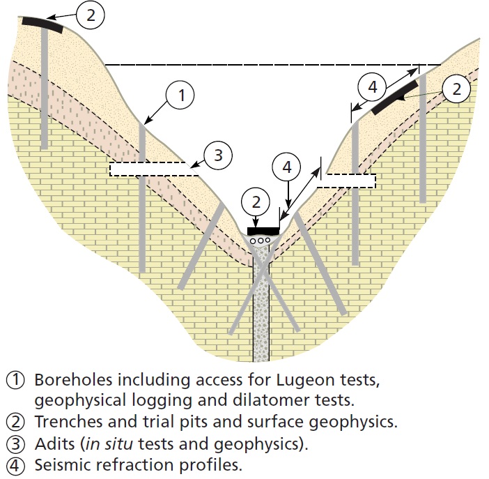
Boreholes. The minimum number of boreholes recommended for dams of less than 50 metres high is 3–4 on each side of the valley and at least 2–3 on the valley floor, preferably inclined and crossed.
Permeability tests. These are usual practice in all dam site studies. The most widely used are Lugeon tests on fractured rock and Lefranc tests on highly permeable rocks and soils. They must be carried out according to their prescribed methods.
Tracer tests are used in karstic areas and in general to investigate permeable materials orfractures of high permeability.
Grouting tests are carried out to estimate grout intake for consolidation or waterproofing treatments of the ground, and as a complement to permeability tests, especially in areas which have previously been identified as more permeable. They consist of injecting a mixture of cement and water (known as slurry) under pressure and determining the flow intake.
Piezometers must be installed in most of the boreholes. The type will depend on the hydrogeological conditions of the ground and the material properties.
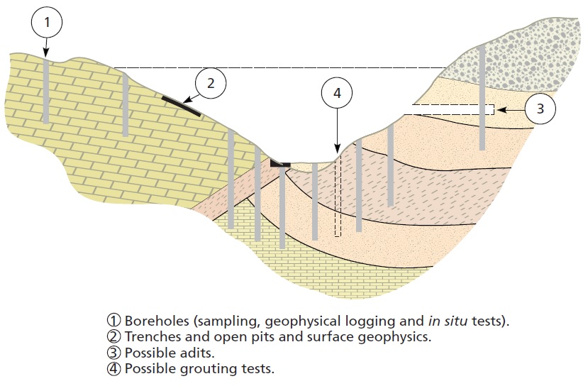
Dilatometer tests. Depending on the type of dam and the rock mass properties, deformation tests with dilatometers are carried out inside the boreholes to obtain the rock deformation modulus.
Adits can provide a direct, large scale observation of the rock mass, needed for concrete dams; they are expensive. They allow tests to be carried out in fault zones and in weak materials. Borings and seismic profiles can be made from these adits complementing those carried out at surface level. They also give access to work areas during the construction and operation of the dam so they should remain connected to it.
Large scale in situ tests. These tend to be used mainly in arch dams, and usually consist of large scale tests on the rock mass or discontinuity planes. The most characteristic tests are direct shear test, flat-jack and plate-load tests. These tests are carried out inside adits or galleries.
Suggested criteria for site investigations of dams
— Site investigations should be carried out in stages using methods in the early stages that cover extensive areas and more detailed and sophisticated ones as the project develops.
— In situ data should be representative of the investigated rock mass and of sufficient quantity to allow statistical analysis.
— Site investigations should be carefully planned and coordinated selecting those methods than can be used for different purposes or can be complementary to each other. Costs and time can be reduced if adequate planning and coordination is carried out.
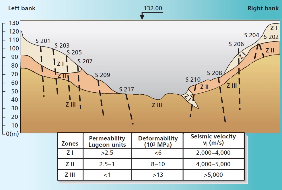
— The overall interpretation of the geological, hydrogeological and geomechanical parameters should lead to the geomechanical zoning of the rock mass foundation (see figure below) that will be used to define the foundation conditions.
— Specific zones of the rock mass such us faults, shear zones, dykes, weathered zones, etc., should be considered as particular points and studied on an individual basis.
— In situ large scale tests are usually carried out in concrete dams. These are limited in number and are located at the critical zones of the rock mass to provide the strength and deformability parameters of the foundations.
Author : Luis I. González de Vallejo and Mercedes Ferrer