In the dynamic realm of geology and engineering geology, efficient surface analysis tools are indispensable. One such tool that stands out is LandSerf, a powerful and freely available application designed for the visualization and analysis of surfaces. This article delves into the features and applications of LandSerf, emphasizing its capability to handle various surface models and its suitability for diverse tasks.
LandSerf emerges as a versatile software application catering to a wide array of geospatial needs. Whether you’re involved in landscape visualization, geomorphological analysis, gaming, GIS file conversion, archaeological mapping, or surface modeling, LandSerf offers a comprehensive suite of tools. What sets it apart is its accessibility, being compatible with Java-supported platforms such as Windows, MacOSX, Unix, and Linux.
LandSerf boasts an impressive set of features that make it a go-to choice for professionals and enthusiasts alike:
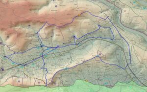
Multi-Surface Model Handling: LandSerf is adept at managing various surface models, including raster Digital Elevation Models (DEMs), vector Triangulated Irregular Networks (TINs), contours, and metric surface networks (MSNs).
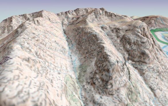
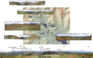
Interactive 3D Viewing: Experience surfaces like never before with interactive 3D viewing and ‘flythrough’ capabilities on platforms supporting OpenGL.
Advanced Visualization Techniques: LandSerf provides a range of powerful visualization techniques, including lighting/shade models, multiple image blending, and dynamic graphical query.
User-Friendly Interface: The application is fully controllable through an attractive graphical user interface, offering ease of use. Alternatively, users can opt for script-based control for more advanced operations.
Raster and Vector Transformation: LandSerf facilitates seamless raster and vector transformations, encompassing tasks like image rectification and map projection.
Multi-Scale Surface Processing: Leveraging quadratic regression, LandSerf enables multi-scale surface processing, catering to diverse analytical needs.
Fractal and Polynomial Surface Generation: Ideal for modeling and simulation, the software supports the generation of fractal and polynomial surfaces.
Parameter and Feature Extraction: Users can extract multi-scale parameters and features such as slope, aspect, and curvature, enhancing the depth of analysis.
Format Compatibility: LandSerf supports the import and export of common raster and vector formats, ensuring interoperability with other geospatial tools.
Garmin GPS Integration: The software facilitates seamless data exchange with Garmin GPS receivers, enhancing fieldwork efficiency.
In conclusion, LandSerf emerges not only as a free and accessible tool but as a powerful ally in the geologist’s toolkit. Its extensive feature set, compatibility with diverse platforms, and user-friendly interface make it an asset for professionals across various domains. Whether you’re navigating the intricacies of surface modeling or conducting in-depth geomorphological analyses, LandSerf stands as a reliable and efficient solution, opening new horizons in the field of geology and engineering geology.
For more information and to download LandSerf, visit LandSerf Official Website.
| Cookie | Duration | Description |
|---|---|---|
| cookielawinfo-checkbox-analytics | 11 months | This cookie is set by GDPR Cookie Consent plugin. The cookie is used to store the user consent for the cookies in the category "Analytics". |
| cookielawinfo-checkbox-functional | 11 months | The cookie is set by GDPR cookie consent to record the user consent for the cookies in the category "Functional". |
| cookielawinfo-checkbox-necessary | 11 months | This cookie is set by GDPR Cookie Consent plugin. The cookies is used to store the user consent for the cookies in the category "Necessary". |
| cookielawinfo-checkbox-others | 11 months | This cookie is set by GDPR Cookie Consent plugin. The cookie is used to store the user consent for the cookies in the category "Other. |
| cookielawinfo-checkbox-performance | 11 months | This cookie is set by GDPR Cookie Consent plugin. The cookie is used to store the user consent for the cookies in the category "Performance". |
| viewed_cookie_policy | 11 months | The cookie is set by the GDPR Cookie Consent plugin and is used to store whether or not user has consented to the use of cookies. It does not store any personal data. |