What is a geological compass?
The geological compass – clinometer is used to measure: (1) the orientation of geological planes and lineations with respect to north; and (2) the angle of dip of geological features with respect to the horizontal.
This allows an accurate record of the geometry of the features to be constructed. The compass – clinometer can also be used in conjunction with a topographic map to accurately determine location.
Types of geological compass
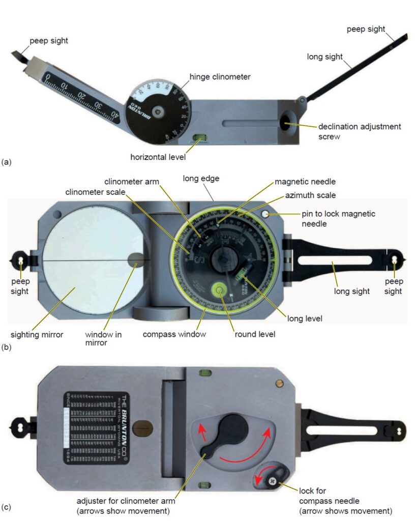
– Brunton compass
There are two main types of compass – clinometer design on the market: the first type is made by Brunton (Figure 1), USA, Freiberger, Germany and Breithaupt, Germany.
– Geological compass-clinometer
The second type is made by Silva and Suunto, both based in Sweden (Figure 2). The Brunton – type compass-clinometer is a more sensitive device because of the in – built spirit levels and the graduation of the scales in 1 ° rather than 2 ° increments.
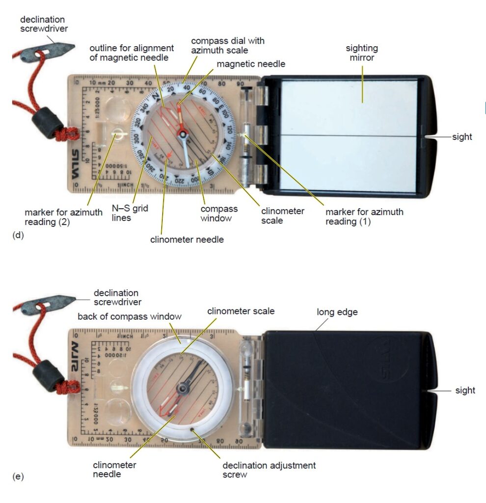
The Brunton – type can also be used for more tasks (see below); however, it is bulkier, more expensive and for some functions more diffi cult to use. The accuracy of the Silva – type compassclinometer is suffi cient for most purposes and is much better designed for directly transferring compass directions to a map. Because the design of the two compass – clinometers is different, their operation for some measurements is also different.
How to use a geological compass?
The most common type of measurement in geology is the orientation of a dipping plane: for instance a bedding plane, a cleavage plane or a fault plane. The following three parameters need to be measured and recorded: (1) maximum angle at which the plane dips (dip magnitude) in degrees relative to the horizontal; (2) the orientation of the plane relative to north (strike, i.e. orientation of the horizontal line defi ned by the plane) in degrees; and (3) the general dip direction because from the strike alone the plane could be dipping in one of two directions at 180 ° to each other.
How to use the Brunton – type compass – clinometer to measure the orientation and dip of a plane using the contact method.
- General orientation
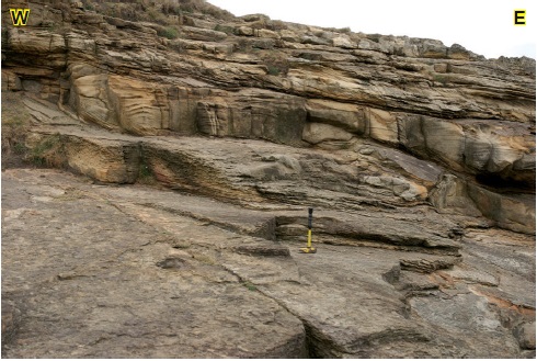
Determine the general direction of strike to within c. 20° by noting where the maximum dip lies; the strike is at 90° to this. In some cases it may be necessary to smooth out the variations on the surface by placing a notebook or clipboard on the bedding plane but take care to ensure that this is not biased by a small irregularity. Hammer shows the plane chosen in this case.
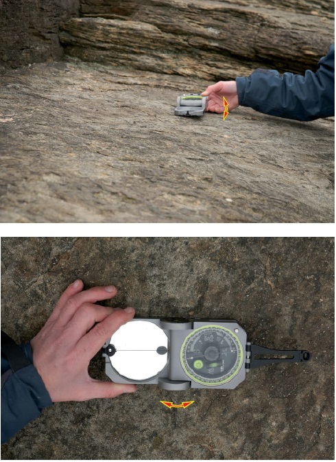
2. Strike direction
Place the long edge of the compass clinometer down where you roughly estimate the line of strike is. Using the round spirit level, position the compass exactly horizontal by both: (i) Tilting the compass about its short axis so it is horizontal (as shown by the red arrow);
(ii) Slightly pivoting the long edge of the compass in contact with the bedding plane about its central point (as shown by the red arrow) to obtain the exact line of strike within your 20° window.
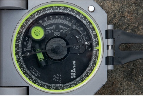
Take the reading of the strike from the dial.
In this case it is 008° or the other end of the line, 188°.
- Dip magnitude
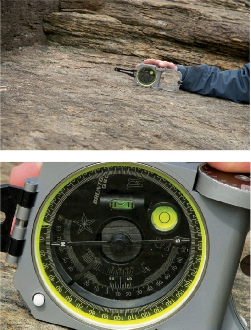
Remembering exactly where the line of strike is, place the long edge of the compass-clinometer at 90° to this on the bedding plane. Ensure that the clinometer scale is on the side in contact with the rock. Move the clinometer arm until the bubble in the long spirit level indicates that it is level.
Read off the maximum dip. In this case it is 12°.
4. Dip direction
The last measurement is the direction of dip to the nearest cardinal point (e.g. NW or SE, E or W). In this case it is east.
5. Record
Record the orientation of the plane in your notebook; in this case 008/12E. Note that the strike is always recorded as a 3-digit number to avoid any confusion and that the degree symbols are not normally shown to prevent any confusion with zeros.
Conclusion
In conclusion, the geological compass is a vital tool in the field of geology and earth sciences. Its ability to measure and record orientation and inclination of geological features, such as rock layers, fault lines, and mineral deposits, plays a fundamental role in understanding the Earth’s history, structure, and processes.
The geological compass allows geologists to make accurate field observations, create detailed geological maps, and formulate hypotheses about the geological history of an area. It aids in the identification of geological structures, the determination of dip and strike angles, and the interpretation of complex geological phenomena.
Furthermore, advancements in technology have led to the development of digital geological compasses, which offer additional capabilities such as data storage, integration with GIS (Geographic Information Systems), and the ability to enhance collaboration among geologists.
In summary, the geological compass remains an indispensable tool for geologists and researchers, contributing significantly to our knowledge of the Earth’s geology and its evolution over time. As technology continues to evolve, the geological compass will likely continue to evolve and adapt, further enhancing its utility in the field of earth sciences.
Source: Authors: Angela L. Coe Tom W. Argles David A. Rothery Robert A. Spicer