Rocklogger App for Android: Your Ultimate Geological Tool
Are you a geologist or rock enthusiast looking for an efficient way to measure the orientation of rock outcrops? Look no further! Rocklogger is the ultimate geological tool designed for Android users. In this comprehensive guide, we’ll explore the features and functionalities of the Rocklogger app, helping you unlock its full potential for your geological endeavors.
Introduction to Rocklogger
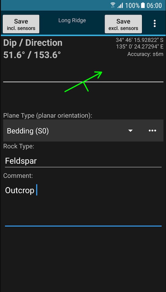
Rocklogger is a powerful Android app that leverages your smartphone’s compass and orientation sensors to measure critical geological parameters. Whether you need to determine dip & dip direction or dip & strike, Rocklogger simplifies the process with just a single click. Additionally, it allows you to save GPS and magnetic field data while providing essential details about the rock plane and type.
Key Features of Rocklogger
Rocklogger boasts an array of features that make it an indispensable tool for geologists and rock enthusiasts alike:
1. Easy Dip & Strike Logging
Logging the dip and strike of rock outcrops has never been easier. Simply place your phone on the rock or plane in any orientation, and Rocklogger will do the rest. The app provides a rotating symbol and quick help features as guides, ensuring accurate measurements.
2. Android Wear Compatibility
For added convenience, Rocklogger offers an Android Wear companion app. With this feature, you can view and save live sensor readings from your phone directly on your smartwatch. This functionality is available in the paid version of the app and simplifies logging on hard-to-reach surfaces.
3. Map Plotting
Visualize your rock outcrop data effortlessly by plotting logs on a map. Rocklogger provides correct dip and strike symbols, making it easier to interpret geological data spatially.
4. Custom Basemaps
In the paid version of Rocklogger, you can access alternate basemaps from various sources, including MapBox, zip files, and the web. This feature enhances your ability to tailor the app to your specific geological needs.
5. Stereonet Plotting and Interpretation
For advanced users, Rocklogger offers the capability to plot poles or planes from logs on a stereonet. By touching the plot, you can identify trends and intersections, making geological analysis more accessible. This feature is available in the paid version of the app.
6. Custom Logging Fields
Tailor Rocklogger to your unique logging scheme with custom text and dropdown fields. This feature, available in the paid version, ensures that the app aligns with your specific geological requirements.
7. Ambient Magnetic Field Logging
Rocklogger goes the extra mile by allowing you to log the ambient magnetic field. This feature can be invaluable for geological studies that involve magnetic field analysis.
8. Integrated Camera Functionality
Capture the essence of your geological findings by launching the camera while logging. Rocklogger automatically saves notes and GPS data to the log file, and it conveniently attaches photos when you send a log via email.
Export and Interpretation
The data you collect with Rocklogger is saved to a .csv file, which can be easily sent to software tools like Excel, Mapinfo, and more for interpretation. Moreover, paid versions of the app offer KML export functionality for use in Google Earth, whether on Android or desktop.
Efficiency and Versatility
Traditional methods of taking strike and dip measurements with a compass or declinometer can be time-consuming, often taking several minutes per rock. Rocklogger revolutionizes the process, enabling you to take multiple measurements in seconds, regardless of the orientation. It even works upside-down, making it perfect for logging overhangs in mines.
Unlock the Full Potential
While the evaluation version of Rocklogger is available for free, it does have some limitations. It restricts you to saving only three records every three minutes and disables features like the stereonet plotter, KML export, and custom basemap options. To unlock the app’s full potential, consider purchasing the Rocklogger Unlocker, which removes these restrictions.
Conclusion
Rocklogger is the ultimate geological tool for Android users, offering a wide range of features that simplify rock outcrop measurement and analysis. Whether you’re a professional geologist or a rock enthusiast, this app is a must-have for your toolkit. Don’t let the limitations of traditional methods slow you down—embrace the efficiency and versatility of Rocklogger and take your geological studies to the next level. Download the app today and unlock a world of geological exploration at your fingertips.
Read more on blog:
- 5 Best Geological Apps for iOS in 2023
- 5 Best Geological Apps for Android in 2023
- Discovering the Benefits of Free Geological Compass on Your Mobile Phone
- How to Construct a Geologic Cross Section: A Step-by-Step Guide
Guest author of the article: Mirza Djedović, B.Sc. geology
