
Geologists are scientists who study the Earth and its composition, structure, processes, and history. They use various techniques to study the planet, including fieldwork, laboratory analysis, and remote sensing. Geologists are typically divided into two main categories: those who study the Earth’s surface processes, and those who study the Earth’s interior processes.
Geologists often need to travel to different locations to study different types of rock formations, minerals, and other geological features. This fieldwork is essential for understanding the Earth’s processes and history, and for finding natural resources such as oil, gas, and minerals. By visiting different locations, geologists can gain a better understanding of the Earth’s geology, the processes that shape it, and the resources that it contains. Additionally, visiting different locations can also help geologists to understand the relationship between different geological features and how they have changed over time. In the following are, TOP 5 locations in Europe to visit:
1.The Giant’s Causeway in Northern Ireland is a unique natural formation of interlocking basalt columns that were formed by ancient volcanic activity.
2.The Isle of Skye in Scotland is known for its diverse geology, including the Old Man of Storr, a large rock pinnacle that was formed by glacial erosion.
3.The Vatnajökull glacier in Iceland is one of the largest glaciers in Europe and is a great location to study glacial geology and the formation of ice caves.
4.The Sistema Central mountain range in Spain offers a diverse range of geological features, including granite peaks, limestone formations and ancient volcanic activity.
5.The Mont Blanc massif in the French and Italian alps is famous for its high peaks, glaciers, and stunning landscape that is shaped by glacial erosion, rock uplift and erosion.
The Giant’s Causeway in Northern Ireland
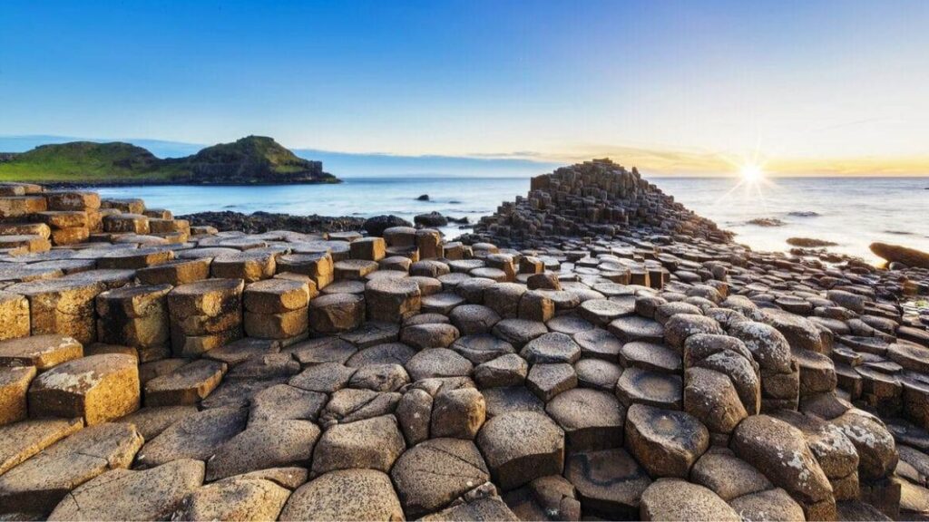
The Giant’s Causeway is a geological formation located in County Antrim, Northern Ireland. It is a unique natural formation of interlocking basalt columns that were formed by ancient volcanic activity. The Giant’s Causeway is also known as a UNESCO World Heritage Site.
The Giant’s Causeway is the result of volcanic activity that occurred around 50-60 million years ago, during the Paleogene period. The volcano erupted, and the lava cooled and solidified to form basalt rock. As the lava cooled, it contracted, and this caused the rock to crack. The cracks formed a hexagonal pattern, and the contraction caused the rock to break into large polygonal columns. These columns are what make up the Giant’s Causeway.
The Giant’s Causeway is considered as a classic example of basaltic columns, a well-known feature in volcanic areas. The unique feature of these columns is the hexagonal shape and how they interlock, which is a result of the cooling process of the lava. The Giant’s Causeway is also a popular tourist destination, not only for its beautiful scenery but also for its geological significance, as it offers a rare opportunity to see a volcanic formation that has been preserved for millions of years.
The Isle of Skye in Scotland
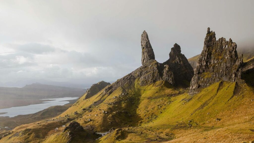
The Isle of Skye is an island located in the Inner Hebrides of Scotland. It is known for its diverse geology and its rugged landscapes, including the Old Man of Storr, a large rock pinnacle that was formed by glacial erosion.
The geology of the Isle of Skye is diverse and complex. The island is made up of a variety of rock types, including gneiss, granite, and Lewisian gneiss, which are some of the oldest rocks in the British Isles. The island also has a rich history of volcanic activity, with many of the island’s peaks, including the famous Cuillin hills, formed by ancient volcanoes.
The island’s geology has been shaped by a variety of processes over millions of years, including tectonic activity, volcanic activity, and glaciation. The most striking feature of the island’s geology is the Old Man of Storr, a large rock pinnacle that stands at over 130 meters high, it was formed by the erosion of the surrounding rock by glaciers during the last ice age. Additionally, the island’s coast is also interesting with sea stacks, arches and other coastal landforms that have been shaped by the constant erosion by the sea.
The Isle of Skye is a popular destination for geologists, as well as outdoor enthusiasts, as it offers a unique opportunity to see the diverse geology of Scotland in one place. The island’s geology provides a fascinating glimpse into the Earth’s history and the processes that have shaped the planet over millions of years.
The Vatnajökull glacier in Iceland
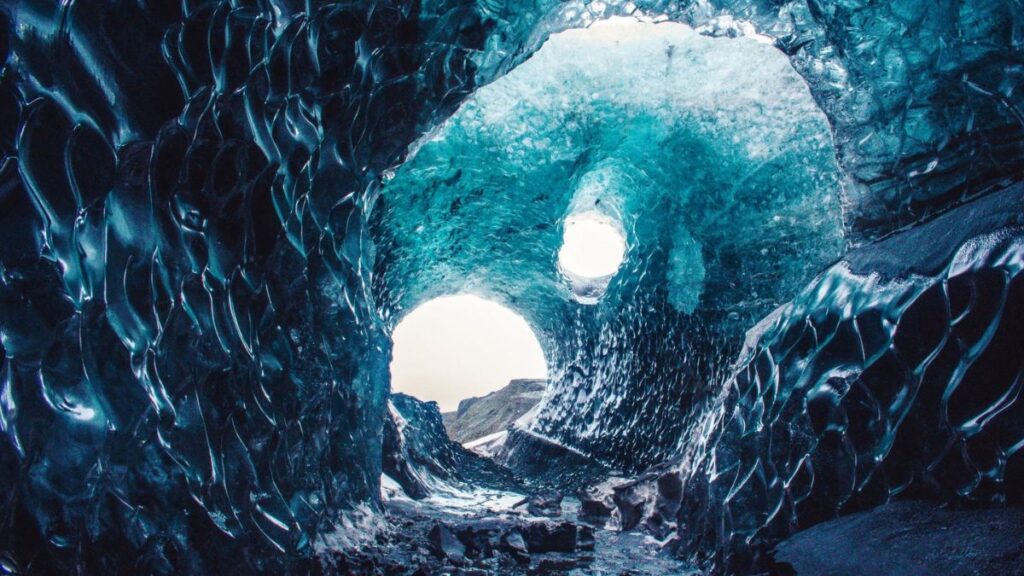
The Vatnajökull glacier in Iceland is the largest glacier in Europe, covering an area of about 8,100 square kilometers (3,100 square miles). Geologically, the glacier sits on top of a massive volcanic system. The glacier is also home to several active subglacial volcanoes, including Bárðarbunga and Grímsvötn. In recent years, there have been several volcanic eruptions beneath the ice, leading to the formation of glacial lakes and jökulhlaups (glacial outburst floods). These events have been known to cause significant damage to infrastructure in the surrounding areas. The Vatnajökull glacier is a unique and dynamic environment, shaped by the interplay between ice and fire.
The Sistema Central mountain range in Spain
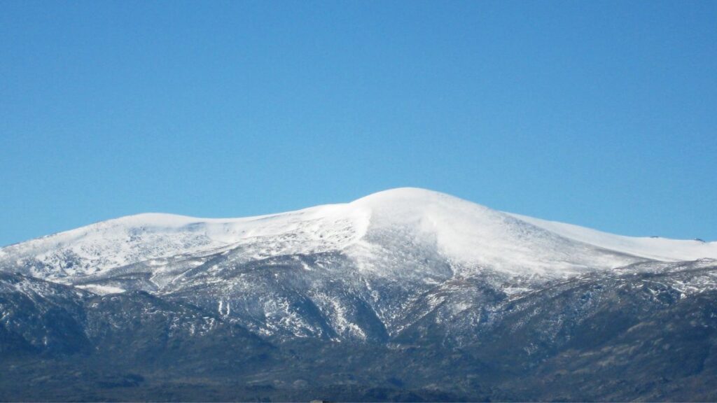
The Sistema Central mountain range in Spain is a system of mountain ranges that runs through the center of the Iberian Peninsula. Geologically, the Sistema Central is composed mainly of granite and other igneous rocks, with some metamorphic rocks also present. The range was formed during the Hercynian orogeny, a mountain-building event that occurred during the Paleozoic era. The Sistema Central has also been shaped by erosion and tectonic activity over time, leading to the formation of its distinctive peaks and valleys. The mountain range is also home to several important mining areas, where minerals such as iron, gold, and lead have been extracted for centuries. The Sistema Central is an important geological formation, with a rich history of mining and human activity.
The Mont Blanc massif in the French and Italian alps
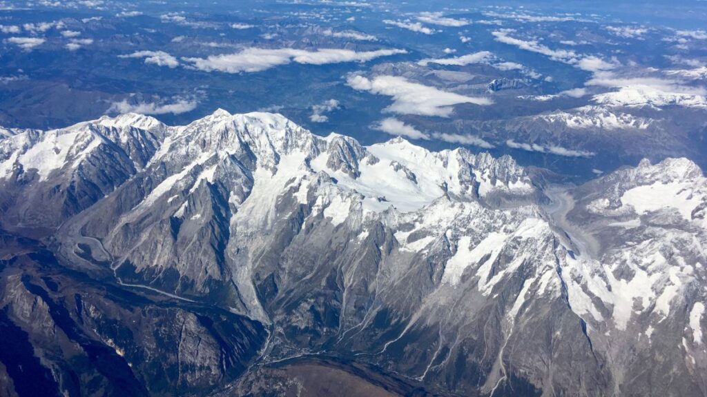
The Mont Blanc massif is a mountain range located in the French and Italian Alps, on the border between France and Italy. It is known for its highest peak Mont Blanc, which is the highest point in Western Europe with a height of 4810 meters.
Geologically, the Mont Blanc massif is composed mainly of granite and gneiss rocks that were formed during the Hercynian orogeny, a mountain-building event that occurred during the Paleozoic era. These rocks were later uplifted and exposed by tectonic activity and erosion, shaping the peaks and valleys of the massif. The Mont Blanc massif is also part of the European Alps, which are a result of the collision between the African and Eurasian tectonic plates during the Tertiary and Quaternary periods. This collision caused the uplift of the massif and formed the highest peaks of the European Alps.
The Mont Blanc massif is an important geological formation and a popular destination for mountaineers and hikers. The rugged terrain and varied geology of the massif make it a unique and challenging environment to explore.
Conclusion
In conclusion, Europe is home to a wide variety of geological wonders that offer a diverse range of features and formation processes. From the unique basalt columns of the Giant’s Causeway in Northern Ireland to the varied geology of the Isle of Skye in Scotland, these five locations are a must-visit for any geologist interested in studying the geological history of Europe. The Vatnajökull glacier in Iceland is a great place to study glacial geology and the formation of ice caves, while the Sistema Central mountain range in Spain offers a diverse range of geological features, including granite peaks, limestone formations and ancient volcanic activity. The Mont Blanc massif in the French and Italian Alps is known for its high peaks, glaciers and stunning landscape shaped by glacial erosion, rock uplift and erosion. These locations are not only a valuable resource for scientific study but also a great destination for outdoor enthusiasts, nature lovers and those who enjoy exploring the natural beauty of the world.
The coordinates of a location
The coordinates of a location are a set of numerical values that indicate the position of a place on the Earth’s surface. They are commonly measured in degrees of latitude and longitude, with latitude measuring the distance north or south of the equator and longitude measuring the distance east or west of the Prime Meridian.
The Giant’s Causeway in Northern Ireland is located at 55.2408° N, 6.5211° W. This means it is located 55.2408 degrees north of the equator and 6.5211 degrees west of the Prime Meridian.
The Isle of Skye in Scotland is located at 57.25° N, 6.15° W. This means it is located 57.25 degrees north of the equator and 6.15 degrees west of the Prime Meridian.
The Vatnajökull glacier in Iceland is located at 64.00° N, 17.00° W. This means it is located 64.00 degrees north of the equator and 17.00 degrees west of the Prime Meridian.
The Sistema Central mountain range in Spain is located at 40.00° N, 4.00° W. This means it is located 40.00 degrees north of the equator and 4.00 degrees west of the Prime Meridian.
The Mont Blanc massif in the French and Italian Alps is located at 45.83° N, 6.86° E. This means it is located 45.83 degrees north of the equator and 6.86 degrees east of the Prime Meridian.
It’s important to note that these coordinates are approximate, and may vary slightly depending on the specific location within each site.
[…] The Geologist’s Guide to Europe: Top 5 Locations to Visit […]
[…] The Geologist’s Guide to Europe: Top 5 Locations to Visit […]
[…] The Geologist’s Guide to Europe: Top 5 Locations to Visit […]